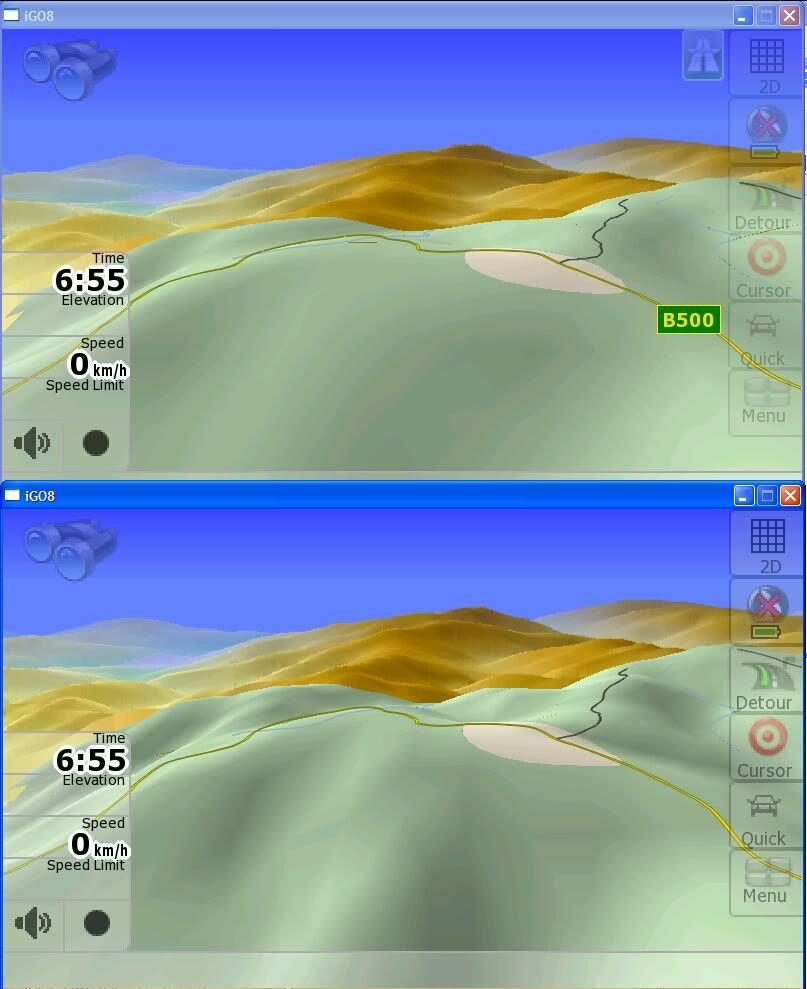
Page 1 of 2 12 LastLast
Results 1 to 20 of 22

Thread: Dem questions.

  1. #1
    Senior Member MrRadio's Avatar
    Join Date
    Jan 2008
    Location
    The depths
    Age
    76
    Posts
    1,331
    Thanks
    608
    Thanked 204 Times in 116 Posts
    Rep Power
    270
    Reputation
    1386

    Default Dem questions.

    What essentially does a Dem folder do as regards to terrain etc and does it require a sys.txt command or similar to make it work..

    Does a DEM folder have to have to match exclusively to the map installed or is one DEM interchangeable between say Sensless and Navteq maps.

    Where does one get the "latest" DEM for either map

    The reason I ask these questions is because I have tested a couple of versions of iGO with and without the DEM folder and it doesn't seems to make a lot of difference.

    I have read this forum extensively looking for these answers but have not yet found what I seek.


Look Here ->
  • #2
    Senior Member

    Join Date
    Nov 2009
    Location
    Australia
    Posts
    1,087
    Thanks
    100
    Thanked 722 Times in 348 Posts
    Rep Power
    314
    Reputation
    5103

    Default

    Top - small dem
    Bottom - Large dem
    Mt Hotham Vic, Oz


    Any mapset will used the same DEM file.
    They are a contour map of the country. Not much to see around suburban areas but start to show well nearer mountains etc.
    There is no real "latest: file as the land mass will only change after an Atomic bomb...
    What country are you in?

    Bazzle
    Last edited by bazzle01; 20-10-10 at 04:28 PM.

  • The Following 2 Users Say Thank You to bazzle01 For This Useful Post:

    MrRadio (20-10-10),xr6falcon (02-11-10)

  • #3
    Senior Member MrRadio's Avatar
    Join Date
    Jan 2008
    Location
    The depths
    Age
    76
    Posts
    1,331
    Thanks
    608
    Thanked 204 Times in 116 Posts
    Rep Power
    270
    Reputation
    1386

    Default

    Quote Originally Posted by bazzle01 View Post
    Top - small dem
    Bottom - Large dem
    Mt Hotham Vic, Oz


    Any mapset will used the same DEM file.
    They are a contour map of the country. Not much to see around suburban areas but start to show well nearer mountains etc.
    There is no real "latest: file as the land mass will only change after an Atomic bomb...
    What country are you in?

    Bazzle
    AU

  • #4
    Junior Member
    Join Date
    Nov 2008
    Location
    Brisbane
    Posts
    246
    Thanks
    141
    Thanked 95 Times in 72 Posts
    Rep Power
    208
    Reputation
    601

    Default

    DEM = Digital Elevation Model. The folder does nothing it is the DEM file within it that does the work. Remember that you will only see the contour information in 3d mode and you must have the right degree of tilt to show the horizon. As you can see from Bazzle01's examples there is not a lot of difference between the DEM files, the larger one has slightly better detail but that's about it. In normal driving I doubt you would notice it.

    Cheers, Ian
    Any sufficiently advanced technology is indistinguishable from magic!

  • The Following 2 Users Say Thank You to Jards88 For This Useful Post:

    MrRadio (20-10-10),xr6falcon (02-11-10)

  • #5
    Senior Member

    Join Date
    Nov 2009
    Location
    Australia
    Posts
    1,087
    Thanks
    100
    Thanked 722 Times in 348 Posts
    Rep Power
    314
    Reputation
    5103

    Default

    Mr Radio

    Do you have DEM files already in the Dem folder?
    What size if so.

    Bazzle

  • #6
    Senior Member MrRadio's Avatar
    Join Date
    Jan 2008
    Location
    The depths
    Age
    76
    Posts
    1,331
    Thanks
    608
    Thanked 204 Times in 116 Posts
    Rep Power
    270
    Reputation
    1386

    Default

    Quote Originally Posted by bazzle01 View Post
    Mr Radio

    Do you have DEM files already in the Dem folder?
    What size if so.

    Bazzle
    Australia.dem = 38,490 KB
    Oceania.dem = 1,392 KB

    What has been said here makes sense then ..... not even a mole hill within cooee of here.

  • #7
    Senior Member

    Join Date
    Nov 2009
    Location
    Australia
    Posts
    1,087
    Thanks
    100
    Thanked 722 Times in 348 Posts
    Rep Power
    314
    Reputation
    5103

    Default

    Thats the small DEM.

    If you ever find the need for larger DEM ask

    Bazzle

  • #8
    Senior Member MrRadio's Avatar
    Join Date
    Jan 2008
    Location
    The depths
    Age
    76
    Posts
    1,331
    Thanks
    608
    Thanked 204 Times in 116 Posts
    Rep Power
    270
    Reputation
    1386

    Default

    Quote Originally Posted by bazzle01 View Post
    Thats the small DEM.

    If you ever find the need for larger DEM ask

    Bazzle
    Please sir, may I have some more?

  • #9
    Junior Member
    Join Date
    Jan 2008
    Posts
    92
    Thanks
    12
    Thanked 0 Times in 0 Posts
    Rep Power
    201
    Reputation
    10

    Default

    I have also been trying to find
    Australia.dem = 38,490 KB and Oceania.dem

    I have the Australia.dem, but don't know if it is the right size?
    have you got a link for those files please?

  • #10
    Senior Member

    Join Date
    Nov 2009
    Location
    Australia
    Posts
    1,087
    Thanks
    100
    Thanked 722 Times in 348 Posts
    Rep Power
    314
    Reputation
    5103

    Default

    Watch this space. uploading now..


    Just use one only in dem folder..

    Bazzle
    Last edited by bazzle01; 22-10-10 at 08:26 AM.

  • The Following User Says Thank You to bazzle01 For This Useful Post:

    MrRadio (21-10-10)

  • #11
    Senior Member MrRadio's Avatar
    Join Date
    Jan 2008
    Location
    The depths
    Age
    76
    Posts
    1,331
    Thanks
    608
    Thanked 204 Times in 116 Posts
    Rep Power
    270
    Reputation
    1386

    Default

    Quote Originally Posted by bazzle01 View Post
    Watch this space. uploading now..


    Just use one only in dem folder..

    Bazzle
    Many thanks Bazzle, I'll give it a go this afternoon

  • #12
    Senior Member MrRadio's Avatar
    Join Date
    Jan 2008
    Location
    The depths
    Age
    76
    Posts
    1,331
    Thanks
    608
    Thanked 204 Times in 116 Posts
    Rep Power
    270
    Reputation
    1386

    Default

    Just one more dem fool question .... which map is the Oceania.dem used with .. and should it even be in the folder.
    Last edited by MrRadio; 22-10-10 at 03:45 PM.

  • #13
    Junior Member
    Join Date
    Nov 2008
    Location
    Brisbane
    Posts
    246
    Thanks
    141
    Thanked 95 Times in 72 Posts
    Rep Power
    208
    Reputation
    601

    Default

    That one is a very low resolution version covering both Australia & New Zealand. You are better off with the individual DEM files for each country.

    Cheers, Ian
    Any sufficiently advanced technology is indistinguishable from magic!

  • The Following 2 Users Say Thank You to Jards88 For This Useful Post:

    MrRadio (22-10-10),xr6falcon (02-11-10)

  • #14
    Junior Member
    Join Date
    Sep 2008
    Posts
    95
    Thanks
    32
    Thanked 32 Times in 24 Posts
    Rep Power
    196
    Reputation
    170

    Default

    Thanks for the explanation guys .. I learned something today. You are great!

  • #15
    Junior Member
    Join Date
    Apr 2010
    Posts
    5
    Thanks
    0
    Thanked 0 Times in 0 Posts
    Rep Power
    0
    Reputation
    10

    Default

    So the higher resolution the DEM file, the more it will read terrain?

    What's the highest resolution version that is available?

  • #16
    Senior Member

    Join Date
    Nov 2009
    Location
    Australia
    Posts
    1,087
    Thanks
    100
    Thanked 722 Times in 348 Posts
    Rep Power
    314
    Reputation
    5103

    Default

    Quote Originally Posted by tangcla View Post
    So the higher resolution the DEM file, the more it will read terrain?

    What's the highest resolution version that is available?
    The largest one in my linky above.

    Bazzle

  • #17
    Junior Member
    Join Date
    Dec 2010
    Posts
    5
    Thanks
    2
    Thanked 0 Times in 0 Posts
    Rep Power
    0
    Reputation
    10

    Default Terrain 'depth' - adjustable?

    I hope this is an appropriate place to post this.. Just wondering if there is a way to adjust the terrain effect. I've looked reasonably thoroughly through the sys.txt file, and also searched, but to no avail.

    The reason I ask is that.. maybe it's just my flawed memory but when I had an earlier version of IGO, I recall the terrain effects as being quite, well, dramatic, and realistic. But that GPS died a horrible wet death.. and now on a new one (8.3.4.117940 with diMka WertVRV 1.1.41) the effect *seems* much, much flatter - and yes, I'm comparing it on the same very hilly stretches of road. Maybe it's just my poor memory, or maybe I just had it zoomed in much more...?

    Thanks for any tips.

  • #18
    Senior Member

    Join Date
    Nov 2009
    Location
    Australia
    Posts
    1,087
    Thanks
    100
    Thanked 722 Times in 348 Posts
    Rep Power
    314
    Reputation
    5103

    Default

    Quote Originally Posted by chrlz View Post
    I hope this is an appropriate place to post this.. Just wondering if there is a way to adjust the terrain effect. I've looked reasonably thoroughly through the sys.txt file, and also searched, but to no avail.

    The reason I ask is that.. maybe it's just my flawed memory but when I had an earlier version of IGO, I recall the terrain effects as being quite, well, dramatic, and realistic. But that GPS died a horrible wet death.. and now on a new one (8.3.4.117940 with diMka WertVRV 1.1.41) the effect *seems* much, much flatter - and yes, I'm comparing it on the same very hilly stretches of road. Maybe it's just my poor memory, or maybe I just had it zoomed in much more...?

    Thanks for any tips.
    Same road..... More ZOOM.

    Bazzle

  • #19
    Junior Member
    Join Date
    Dec 2010
    Posts
    5
    Thanks
    2
    Thanked 0 Times in 0 Posts
    Rep Power
    0
    Reputation
    10

    Default

    Quote Originally Posted by bazzle01 View Post
    Same road..... More ZOOM.

    Bazzle
    Yep, I think you're right, now that I've done a few more experiments... Spoke too soon - thanks!

  • #20
    Senior Member

    Join Date
    Nov 2009
    Location
    Australia
    Posts
    1,087
    Thanks
    100
    Thanked 722 Times in 348 Posts
    Rep Power
    314
    Reputation
    5103

    Default

    Quote Originally Posted by chrlz View Post
    Yep, I think you're right, now that I've done a few more experiments... Spoke too soon - thanks!
    You can save your setting as well. Touch screen and hold one of the 4 buttons that come up ( I use the left one for modded pages) and select save.

    You can also change terrain contour colors by swapping dayheightcolormap.bmp in ui_igo8/common


    Bazzle

  • The Following 2 Users Say Thank You to bazzle01 For This Useful Post:

    blindpete (18-12-10),chrlz (20-12-10)

  • Page 1 of 2 12 LastLast

    Bookmarks

    Posting Permissions

    • You may not post new threads
    • You may not post replies
    • You may not post attachments
    • You may not edit your posts
    •